 |
||

|
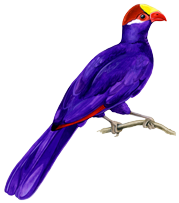
The Violet Turaco, Musophaga violacea; with open wings the scarlet of the flight-feathers is striking. Not wholly dependent on climax forest but certainly typical of it – the reason the bird was chosen locally for the logo of Farasuto Forest Community Nature Reserve |
Hydrology – the importance of water at Farasuto.
Water is crucial to Farasuto’s Forest, but less so for the woodland part of the reserve.
The Gambia’s rains, broadly June to October, will probably deliver the right amount of water each year, a total of perhaps 1300mm (54”) with around 500mm (21”) in August alone. In the British context the Gambia’s August figure is about as much as East Anglia can expect in a year while the country receives annually slightly less than do the tops of the Welsh mountains.
The result is wet season humidity in the heat when average temperatures are only a degree or two lower than in the dry season, along with the mud and the mosquitoes and a great deal of human social disruption. Tourism comes to a virtual standstill and for many people priorities shift to the fields back in their home village.
During the five wet months vegetation grows fast, not least in the remaining deep, dark forests. In here moisture is retained by the soil as the intensity of the sun is intercepted by the forest canopy. While temperatures and humidity are both high the bright light penetrates only as mobile patches as the sun moves across the sky. It is a time of plenty for vegetarians and others up the food chain and many plants and animals chose to reproduce now with food and cover for their offspring available in abundance.
Long-term rainfall changes.
There are suspicions that the Gambia’s annual rainfall total is declining and this is being followed up with the meteorological office. If true there could be worrying implications for Farasuto and of course all the other relict forest patches in the country.
There are reports that the biggest trees in Abuko forest are dying in their tops and the suggestion is that it may be the result of lack of water and the lowering of below-ground water levels. At the time of writing it is not known if there is a water-level monitoring programme at Abuko, though “the reserve was protected as a water catchment area in 1916” (Birdlife International, Important Bird Area Factsheet GM001). There may be water-level information available from Abuko and searches will be made for it.
The water situation at Farasuto.
|
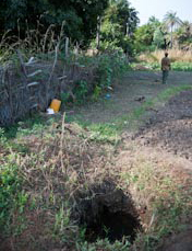
An open well within a few metres of the NE corner of the forest, used for watering the fields there, the water here visible only a metre or so below ground level. In contrast water levels in wells on the south side of the forest, again only metres from the forest edge, are some 3 or 4 metres lower. |
It is important that we know and understand the current water situation, the hydrology, at Farasuto. Current conditions must be established over the next year or two for years can vary considerably – the rains of 2008 were exceptionally heavy for example. Equally important is that the situation should be monitored in the long term.
The nearest rainfall measurements are and will continue to be from the International Airport only eight miles away to the north-west. Farasuto’s ground-water will be monitored at a series of ‘dip-wells’ (piezometers) within and around the site. Piezometers are simply narrow plastic pipes set down into the ground from which water-depth measurements can be made at regular intervals.
|
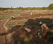
The women of Kuloro working in their fields with the forest behind the fence in the distance. The medium-term intention is to move the fields and allow the forest to regenerate in this area. |
The network of piezometers will be put in place during the dry season of 2009 and will be monitored. While it will not be possible to ‘order’ more rain (we are not likely to ‘request’ less) at least we will know what the true situation is into the future. The fact that Farasuto lies so close to Gambia’s main river and is only slightly above the level of the tidal high-water line gives some encouragement to the hope that water levels there will be maintained.